GeoCache Information |
| Helpful Links: GeoCaching.com |
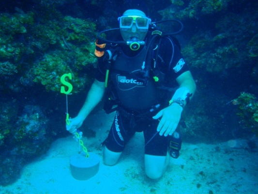
| This is the "Sometimes Island - Scuba" geocache. Located off Windy Point, Lake Travis, Austin, TX. |
| GC1HEGZ N 30 degrees, 24.688 minutes W 97 degrees, 54.134 minutes 577 feet above sea level ----------------------------------- Placed on 10/21/2008 |
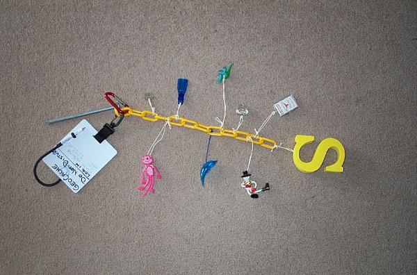
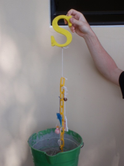
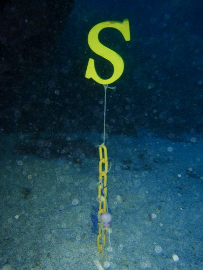
| Underwater Cache on Lake Travis, NW of Sometimes Island Sometimes Island is a feature that appears as the lake level drops. This cache requires a certified SCUBA diver. The Longitude and Latitude coordinates are reasonably accurate. The depth depends on the current lake level. The elevation of the cache is 577 feet above sea level. It is left to the diver to calculate this to depth underwater. The container for this cache is a yellow plastic chain with a yellow foam rubber "S" on the end. The chain is attached to the lake bed by an 8" galvanized nail. The chain holds the treasures. Each treasure is attached to the chain by a looped string. Given a long enough loop, the treasure can be removed or placed without using a knife. Please leave the slate and foam rubber "S" attached. The slate is used as the log and the "S" is used to locate and suspend the cache. The "S" floats, pulling the chain against its anchor. The "S" is easily seen as you pass by. If you plan on placing treasures into this cache, they should be plastic, rubber, or something else that will not corrode over time. Best to use items with no metal pieces. A piece of string with a loop slightly larger than the item works well for attaching treasures. Originally, the cache's treasures were; Red Anodized Carabiner 1977 Canadian Quarter Rubber Fin Rubber Dolphin Glass Heart Pendant Pink Panther Dinosaur Clown Unique UT Keychain |
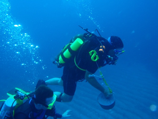
| This is the "Clearwater Paradise - Scuba" geocache. Located off Guanaja Island, Honduras. |
| GC1T16F N 16 degrees, 31.133 minutes W 85 degrees, 51.968 minutes 63 feet below sea level ----------------------------------- Placed on 06/05/2009 |
| Underwater cache off Guanaja, Islas de la Bahia, Honduras , near the Northernmost point of the Island. This cache is so named for the truly Clear Water of this Paradise! This cache requires a certified SCUBA diver. The Longitude and Latitude coordinates describe the buoy that you can attach to your boat, near the cache. Follow the buoy line down to the anchor point (a large rock with lots of coral). Then proceed South, to the next big rock. Behind this second rock, tucked away a bit, is the cache. The depth is 63 feet below sea level. This depth may change slightly due to tide. But the cache is anchored on the bottom, in sand. The original idea was to place the cache behind the buoy line rock. There is a nice little open cave there. When attempting to place the cache there, I looked left and saw sand, ahead was a Cleaner Shrimp. I was fully inside the "cave" when I looked right... There, was a 5 foot green Moray Eel, out of his hole and inches from me!! That's when I decided to use our "backup" location! The container for this cache is a yellow plastic chain with a yellow foam rubber "S" on the end. The chain is anchored to the ocean bed by an 8" galvanized nail cemented into a block. The block is buried in the sand to keep it in place. The chain holds the treasures. Each treasure is attached to the chain by a looped string. Given a long enough loop, the treasure can be removed or placed without using a knife. Please leave the slate and foam rubber "S" attached. The slate is used as the log and the "S" is used to locate and suspend the cache. The "S" floats, pulling the chain against its anchor. The "S" is easily seen as you pass by. If you plan on placing treasures into this cache, they should be plastic, rubber or something else that will not corrode over time. Best to use items with no steel pieces. A piece of string with a loop slightly larger than the item works well for attaching treasures. Originally, the cache's treasures were; o Pink Duck o US Gold $1 Coin o Taco Shack Keychain o Blue Dolfin o US Penny |
| This is the "Shaker Plant for Mansfield Dam" geocache. Located off Hippie Hollow, Lake Travis, Austin, TX. |
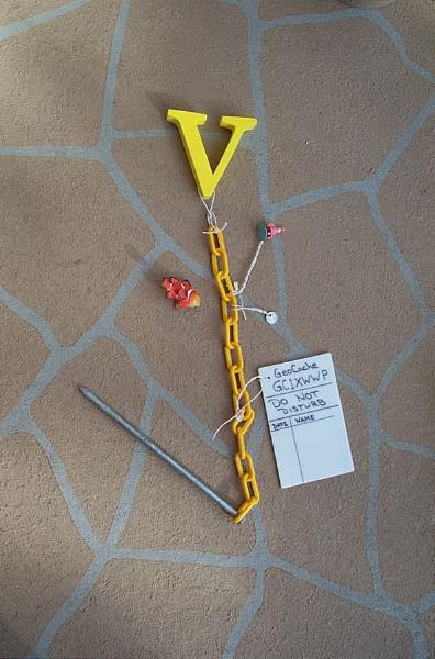
| GC1XWWP N 30 degrees, 24.430 minutes W 97 degrees, 53.144 minutes 583 feet above sea level ----------------------------------- Placed on 08/29/2009 |
| Underwater cache on Lake Travis, SE of Windy Point. This cache requires a certified SCUBA diver. The Longitude and Latitude coordinates are accurate. The depth depends on the current lake level. The elevation of the cache is 583 feet above sea level. It is left to the diver to calculate this to depth underwater. This cache is so named for the "Shaker Plant" that existed during construction of the Marshall Ford Dam. The dam is one mile south of the cache location. The Shaker Plant processed rock according to size. The plant is currently underwater, but during construction of the dam, it was along the banks of the river. The Marshall Ford Dam, as it was called during construction, was renamed Mansfield Dam in 1941. The construction took place from 1937 to 1941. The container for this cache is a yellow plastic chain with a yellow foam rubber "V" on the end. The chain is attached to the lake bed by an 8" galvanized nail. The chain holds the treasures. Each treasure is attached to the chain by a looped string. Given a long enough loop, the treasure can be removed or placed without using a knife. Please leave the slate and foam rubber "V" attached. The slate is used as the log and the "V" is used to locate and suspend the cache. The "V" floats, pulling the chain against its anchor. The "V" is easily seen as you pass by. If you plan on placing treasures into this cache, they should be plastic, rubber or something else that will not corrode over time. Best to use items with no steel pieces. A piece of string with a loop slightly larger than the item works well for attaching treasures. Originally, the cache's treasures were; Rubber Clownfish 1995 Jamaican Dollar (worth 1 cent US) Patrick Star (SpongeBob character) |